HCFCD Seeks to Enhance its Gauge Adjusted Radar Rainfall System
6/5/25 – Harris County Flood Control District (HCFCD) is seeking to negotiate an agreement with the University of Oklahoma to help enhance the county’s Gauge Adjusted Radar Rainfall system. See Item 103 on the 6/12/25 agenda.
What is Gauge Adjusted Radar Rainfall?
Gauge Adjusted Radar Rainfall (GARR) systems estimate rainfall by combining radar-based precipitation estimates with ground-based rain-gauge measurements. The two together produce more accurate rainfall data over wider areas.
- Radar can provide rainfall data over large areas with high frequency (e.g., every 5 minutes), but it’s prone to errors due to beam blockage, calibration issues, or interpreting non-rain targets (such as birds or dust) as rain.
- Rain gauges give point-accurate rainfall measurements, but huge distances/gaps exist between gages. And rainfall is rarely uniform across wide areas.
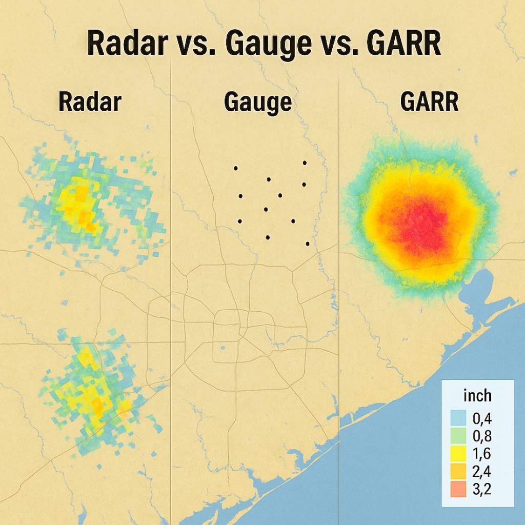
Gauge adjusted radar rainfall systems blend both types of data. They use the broad coverage of radar but “correct” or adjusts the radar estimates using actual gauge readings. Great advances in the systems have been made in recent years.
Is It Good?
Yes. GARR is generally considered superior to using radar or gauges alone. It is widely used by agencies like the National Weather Service, USGS, and local flood control districts (e.g., HCFCD).
According to ChatGPT, the systems offer multiple benefits.
Benefits of Gauge Adjusted Radar Rainfall
| Benefit | Explanation |
|---|---|
| Improved Accuracy | Combines radar’s spatial resolution with gauge accuracy, reducing biases in radar-only estimates. |
| Better Coverage | Provides rainfall estimates across areas with few or no gauges |
| Real-Time Utility | Enables near real-time rainfall mapping, critical for flood forecasting and emergency response. |
| Hydrologic Modeling | Offers high-resolution inputs for stormwater modeling, floodplain mapping, and watershed management. |
| Event Verification | Allows engineers and flood managers to verify how much rain actually fell over an entire basin during a storm. |
How is GARR Used?
GARR data is often used in:
- Post-storm analysis
- Designing detention basins
- Flood alert systems
- Atlas 14 and extreme rainfall calibration
GARR systems are widely used for both real-time monitoring and hydrologic planning. And they are particularly valuable in flood-prone areas.
Success Stories
Harris County Flood Control
During Hurricane Harvey in 2017, GARR data provided near real-time insight into rainfall distribution — helping emergency managers prioritize rescues, issue flood alerts, and allocate resources.
Post-storm, GARR helped analyze where detention basins were effective and where flooding exceeded expected design thresholds.
HCFCD reportedly credits GARR with saving lives and informing infrastructure improvements after Harvey.
San Antonio River Authority (SARA)
SARA integrated GARR into its real-time models to monitor stormwater flow in the river basin. It:
- Improved rainfall inputs to models that simulate flooding during storms
- Enabled automated forecasts of creek levels and road closures
- Reduced false positives/negatives from radar-only systems.
They used it to improve public safety, automated alerts and floodgate operations.
North Carolina
Mecklenburg County (Charlotte) uses GARR to fill data gaps across watersheds and create real-time flood forecasts with more accurate rainfall inputs.
They credit GARR systems with improved warning lead times and better informed design updates for critical infrastructure like culverts and detention ponds.
Recent Advances in GARR
HCFCD hopes to improve accuracy and operational capabilities that support improved flood forecasting. The District did not respond with more specifics, but GARR technology has improved greatly in recent years. Advances include:
1. Integration of AI and Machine Learning
Artificial intelligence (AI) and machine learning techniques are transforming GARR systems. These technologies improve the calibration between radar data and rain gauge measurements, leading to more accurate rainfall estimates. For instance, deep learning models have been employed to enhance precipitation “nowcasting” for emergency response. arxiv.org
2. Enhanced Data Assimilation Techniques
Advances in data assimilation now allow seamless integration of GARR data into hydrological models. This improves the predictive capabilities of models, enabling more accurate flood forecasting given the geographic and temporal variability of rainfall.
3. Development of High-Resolution GARR Products
Companies like AEM have developed GARR products with resolutions as fine as 1 km² and temporal resolutions of 5 minutes. Such resolution is essential for urban planning, infrastructure design, and real-time flood monitoring.
4. Application in Urban Flood Management
More and more, GARR systems help manage flood risks in urban settings. For example, during the unprecedented rainfall event in the United Arab Emirates in April 2024, GARR data played a crucial role in analyzing the hydrologic and flood impacts, highlighting the need for improved flood forecasting systems in rapidly urbanizing regions.
5. Expansion of Historical Data Archives
Organizations like OneRain have expanded their historical radar data archives, providing GARR data back to 1993. This helps researchers and planners analyze trends, climate, and infrastructure resilience. Such advances make GARR systems more valuable tools in modern hydrological practices and disaster risk reduction strategies.
Looking for a summer science project for your student? Here it is.
Posted by Bob Rehak on 6/5/25
2837 Days since Hurricane Harvey
The post HCFCD Seeks to Enhance its Gauge Adjusted Radar Rainfall System appeared first on Reduce Flooding.
You must be logged in to post a comment.